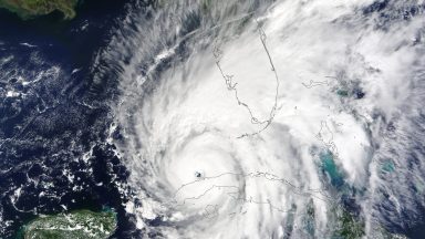

Florida has already dealt with two major hurricanes: Helene and now Milton. But could there be a third storm on the horizon? As Milton makes landfall off the west coast of the Sunshine State, the National Hurricane Center (NHC) has been monitoring other storms and tropical systems around the world. And right now, one tropical development could become Hurricane Nadine if it intensifies.
Days before Hurricane Milton closed in on Tampa, officials warned residents to evacuate. Counties that were issued evacuations included Citrus, Collier, Hernando, Hillsborough, Lee, Manatee, Pasco, Pinellas and Sarasota. Although Orlando was not issued a mandatory evacuation, tourist attractions such as Walt Disney World and the city’s airport announced temporary shutdowns for Milton.
Learn more about the path of the tropical development that could become Hurricane Nadine, below.
Will There Be Another Hurricane After Milton?
At the time of publication, the tropical system was dubbed Invest 93L, according to multiple outlets. If it develops any further, it will be called tropical storm Nadine, which could then intensify into a hurricane.
Is Tropical Storm Nadine a Hurricane?
Invest 93L is currently weakening in the southern Atlantic Ocean, but there is still a chance it could strengthen into a hurricane after Hurricane Milton strikes Florida. The next name of the 2024 Atlantic hurricane season is Nadine.
🚨Hurricane NADINE could follow closely after Milton makes landfall! 🌀
Current Hurricane Milton Information:
Landfall expected: Between 1-2 AM on Thursday morning (overnight)
Sustained winds: 165 MPH
Gusts reaching: 190 MPH
Storm surge: 15-20 feet
The heart of hurricane… pic.twitter.com/i8TAEfUGB0
— DEL (@delinthecity_) October 9, 2024
What Is the Current Path of Nadine?
The current path of the tropical system is off the east coast of Florida. The National Hurricane Center (NHC) announced that Nadine’s “upper-level winds are forecast to become too strong for further development later tonight.” Therefore, it is expected to dissipate.
“Although environmental conditions appear only marginally favorable for additional development, a short-lived tropical or subtropical storm could form today or this evening while the low moves northeastward to east-northeastward at around 15 mph,” the NHC revealed. “Upper-level winds are forecast to increase later tonight, which should limit any chances for further development.”
If Invest 93L becomes Hurricane Nadine, Florida could potentially face further destruction. Milton is expected to cause widespread power outages and massive destruction from its intense winds. The storm fluctuated between a Category 4 and a Category 5 multiple times before it made landfall. Multiple tornadoes also formed across Florida hours before Milton struck Florida.


